-
From
CGIAR Initiative on Livestock and Climate
-
Published on
15.01.24
Pastoralists in the arid and semi-arid rangelands of Kenya are increasingly facing new challenges caused by greater pressures on land and resources and climate change. This has led to rangeland degradation and weakening of customary institutions that in the past managed these lands. In response to these trends, ILRI and its partners have developed participatory rangeland management (PRM). This community-led process strengthens local management institutions, promotes greater involvement of women and supports communities to develop and implement a rangeland management plan.
PRM has its origins in Ethiopia and has proven to be highly successful in assisting communities to better manage their lands. Learning from these experiences, PRM was piloted in Baringo County, Kenya, with funding from the EU-supported Piloting Participatory Rangelands Management project. Subsequently, it was then strengthened with support from the CGIAR Research Initiative on Livestock and Climate.
The project is now being scaled by Accelerating Impacts of CGIAR Climate Research for Africa (AICCRA), to enhance its capacity-building effort in additional counties for wider adoption of PRM. As part of this scaling process, PRM was introduced in Arbahajan Ward, Wajir West Subcounty, Wajir County in 2023. This area, which is more arid than Baringo, presents a distinct context and unique set of challenges.
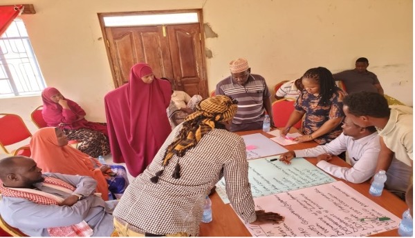
Building on this, ILRI collaborated with the Wajir county government and the Resources Conflict Institute (RECONCILE) to conduct an extensive stakeholder mapping exercise in September 2023. This exercise, serving as a critical first step in the PRM process, not only produced a stakeholder map but also provided an opportunity to foster shared understandings and greater cohesion among participants- essential elements for the successful implementation of PRM.
The significance of stakeholder mapping
Given the intricate nature of rangeland management and its diverse impacts, involving stakeholders representing various interests is not only beneficial but also necessary.
Stakeholder mapping comprehensively assesses those who use and interact with rangelands, offering an insightful overview of individuals, groups and organizations with vested interests in a specific rangeland area. This facilitates a deeper understanding of the interactions between them.
The process creates a visual representation capturing the array of interests, finds connections between stakeholders and reveals varying perceptions stakeholders have of each other. Additionally, it highlights which stakeholders wield the most significant influence in the eyes of others.
A Diverse Representation of Stakeholders
This process proved especially valuable in Arbahajan Ward, where communities and other stakeholders identified a diverse representation of actors including wildlife and livestock, and the following groups:
- Herders and pastoralists: Central to the rangeland ecosystem, herders and pastoralists depend on these landscapes for grazing and watering their animals, playing a crucial role in livestock management.
- Women’s groups: Making significant contributions to rangeland utilization, women’s groups engage in activities enhancing their families’ well-being and the local economy, including small-scale farming, pasture production and the collection of medicinal herbs.
- Charcoal burners: Involved in extracting charcoal from trees and shrubs, their activity offers economic benefits, but carries negative environmental consequences such as deforestation and habitat destruction.
- Poachers: Engaging in illegal hunting and capturing wild game, they exploit rangelands for their gain and pose a significant threat to wildlife populations.
- Wildlife and livestock: The primary beneficiaries of rangeland resources, they rely on these areas for essential needs such as water, forage and essential minerals.
- Urban dwellers and the business community: Indirectly benefiting from rangeland resources, they rely on these landscapes for clean water and a healthy environment.
- Institutions (schools, hospitals, dispensaries): Rely on rangelands for essential services, institutions use rangeland resources such as firewood for heating and cooking.
Stakeholder mapping in Arbahajan Ward is a crucial step towards understanding the complex web of interests and relationships in rangeland management.
This comprehensive approach will pave the way for effective and sustainable participatory rangeland management, benefiting both the environment and the diverse stakeholders who rely on these landscapes for their livelihoods.
The next step in the PRM process is to better understand the rangeland resources, and a participatory rangeland resource assessment is planned for later this month.
Header image: Participants discuss important rangeland stakeholders in Arbahajan Ward, Wajir County, Kenya. Photo by Allan Akivaga/RECONCILE.
Story by Allan Akivaga, Advocacy officer, and Irene Mukalo, Head of Programs, at RECONCILE.